← Back
Europe’s satellites focus on forest fires in the Amazon
International attention has focused on massive forest fires that are currently affecting the Amazon in South America. In 2019, more than 70.000 fires have been registered in Peru, Bolivia, Paraguay and Brazil. In order to monitor the extent of the damage, Copernicus Emergency Management Service (EMS) – RAPID MAPPING was activated by Germany’s Crisis Management Centre (GMLZ) on August 24th, 2019. SIRS, a subsidiary of CLS Group, is one of the H24/7 production sites involved in producing data and maps derived from European Earth Observation satellite images.
The Copernicus Emergency Management Service (EMS) provides free of charge mapping products derived from Earth Observation data to any authorized user in the field of crisis management throughout the world.
CLS Group contribution:
Thanks to its long-term experience in producing geospatial data derived from aerial and satellite imagery with expertise in the various thematic classification techniques, SIRS, part of CLS Group, works closely alongside seven international partners, led by e-GEOS, to operate the Copernicus EMS Rapid Mapping service.
SIRS produces three types of standardized maps within the framework of this cooperation:
- Reference maps: to ascertain the situation before the event,
- Delineation maps: to assess the geographical extent of the event,
- Grading maps: to evaluate the intensity and scope of the damage resulting from the event.
Monitoring forest fires in the Amazon
In the case of the ongoing fires in the Amazon, three maps based on Sentinel-2 and Sentinel-3 imagery were ordered by Germany’s Crisis Management Centre (GMLZ). SIRS delivered one of the mapping products to show the extent of fire damage in Brazil, Rondonia region.
More information and downloadable products on the web portal: https://emergency.copernicus.eu/mapping/list-of-components/EMSR383
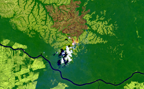
About the title image
An RGB image from Copernicus Sentinel-2A satellite acquired on 29/08/2019. The fire is located between Amazonas and Rondônia, 200 km east of Porto Velho, near Rio Jiparana. Image credit: Sentinel-2A (2019) (acquired on 29/08/2019 at 14:27 UTC, GSD 20.0 m, approx. 0.1 % cloud cover) provided by the European Union and ESA.
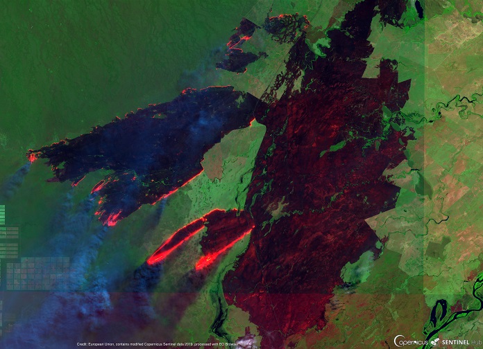
Other fires seen by European satellites between Brazil, Paraguay and Bolivia near the town of Corumba on August 25th
Crédit: European Union. Contains modified Sentinel EO data modified by EO Browser.