← Back
Countdown to the World Congress for Biodiversity

In 100 days, the World Congress for Biodiversity will be held in Marseille, France, a strategic meeting for the future of our fauna and environment. How can space play a role in the balance to be found between economy, sustainability and respect for our ecosystems? There are many threats to biodiversity: global warming, poaching, urban expansion, pollution, and deforestation.
CLS was created by CNES in 1986 to observe, study, understand and protect our planet. Year after year, CLS has developed and deployed innovative space solutions to understand and protect our biodiversity and environment. For more than 30 years, CLS has been contributing to the study of biodiversity, the fight against eco-crime, the observation of urban growth and the taking of compensatory measures for our environment.
Monitoring biodiversity
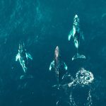
 On the CLS control centre’s image screen, the Earth in orthographic projection is rotating faster than usual. Thousands of dots of all colours are shown. These 8000 dots represent the animals that are tracked every month from space using the ARGOS system.
Giant jellyfish, dolphin, manta rays, turtle, lynx, caribou, stork, golden eagle, cuckoo eagle—whether they are on land, in the air or in the sea, the satellite watches over them, observes them, and enables scientists to study their every movement. By understanding them, we can better protect them. Each kind of animal has its own beacon: birds are equipped with a small backpack, land animals have collar, and in the seas, a pop up with a light sensor is used for species that do not come to the surface. A rugged, specially adapted marinized beacon is placed on the shell or back of the animals to be protected. As we are concerned with the animal’s well being, the device is light—never more than 3% of its weight
Observing environmental conditions
How can we understand and protect a species without understanding its environment?
At CLS, more than 150 environmental parameters are regularly monitored, such as water temperature, currents, phytoplankton and CO2 concentration. These parameters provide information on the animals’ preferences and on the impact of changes in those factors.
Fighting eco-crime
Environmental crime seems to be spreading internationally. Some are calling for the recognition of environmental crime: ecocide. But how can such a crime against biodiversity, the environment and ultimately a crime against future generations be defined? Beyond individual poaching or forest fires, ecocide refers to the most serious acts: international trafficking in toxic waste, massive illegal exploitation of natural resources and precious metals, or international trafficking in protected species.
Fighting environmental crime therefore means ensuring the security of the planet.
Since the 2000s, CLS has been deploying surveillance systems tailored to the needs of the authorities, based on location and data collection, Earth observation and the detection of illegal activities such as: illegal mining, illegal fishing, illegal logging, pollution and poaching. CLS uses all the means and skills we have to offer the best solution for fighting the most serious crime of willful damage.
Urban expansion and compensatory measures
 There have always been cities ahead of their time! Greater Lyon is one of these visionary communities that is trying to ensure that urban growth happens in symbiosis with nature. Greater Lyon is a large urban area made up of 59 municipalities. To control its expansion and make life more pleasant for its 1.5 million inhabitants, while respecting biodiversity, the Lyon metropolis chose SIRS, a CLS subsidiary, to map and characterize its urban vegetation as part of a major ecological management program. As part of the project, SIRS developed new methods to meet the needs of Greater Lyon. Users will be able to produce 3D cartographic renderings that are useful for heat island simulations, pollutant diffusion, etc.
SIRS provides: maps listing the main types of vegetation on a very large scale, databases for operational use, information on ecological and plant corridors, and indicators for monitoring space consumption. All this the strategic information improves knowledge of the environment in order to decide on compensatory measures and integrate vegetation in trying to adapt to climate change.
Related Posts:
 New step for the Indonesian Maritime Meteorological System (MMS1) delivered by CLS and its partners : High Performance Computing is now operational at BMKG HQ
 CLS, Data Partner for Our Planet Ocean
 CLS’ Water Platform: Digitizing Water Resilience