← Back
CLS, Space sentinels for endangered species

According to a recent study, the sixth mass extinction of wildlife on Earth is accelerating with more than 500 species of land animals currently on the brink of extinction and likely to be lost within 20 years. Unlike previous extinction events caused by natural phenomena, the 6th mass extinction is driven by human activity and is one of the most serious environmental threats.
Since its creation nearly 40 years ago, CLS has, and continues to, develop innovative space solutions to monitor and protect both biodiversity and the environment and provide stakeholders with the necessary tools to sustainably manage the planet’s resources and mitigate the impacts of climate change.
Humanity relies on biodiversity for its health and wellbeing. The COVID-19 pandemic is just one example of how the loss of animal habitats through unsustainable use of land, water and energy use, pollution and climate change affects the global population.
Since its creation, CLS has been working with scientists, land managers, governments and NGOs to develop solutions using space technology to help address some of the causes of this mass extinction.
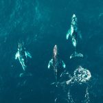
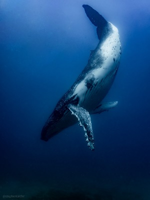
Biodiversity: Better knowledge to provide better protection
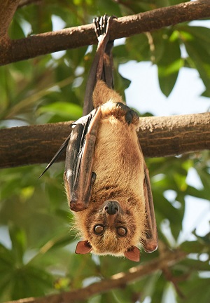
In order to protect a species, we need to understand it. Often referred to as the first space IoT dedicated to the environment, the Argos system has helped revolutionize our knowledge in terms of animal migrations and animal behavior. Since its launch in the 80’s, over 200,000 animals have been tracked with Argos using special beacons and providing strategic information used to implement effective conservation methods.
Protecting biodiversity is one of CLS’ core values which is why, in 2018, CLS’ subsidiary Kinéis was created to revolutionize the Argos system. In less than a year, Kinéis will be launching a unique constellation capable of tracking hundreds of thousands of animals each month in near real-time so the scientific community can gain more understanding and thus better protect wildlife.
 Species protection: managing their environments
Part of protecting a species means protecting its environment. Experts at CLS have been using Earth Observation data, Geographic Information Systems and Argos data to conserve ecosystems, sustainably manage land and water resources, fight pollution and mitigate certain impacts of climate change.
Marine Protected Areas
CLS has been lending its expertise in wildlife monitoring for over 30 years providing in-depth knowledge on the behavior, presence, interactions, migration corridors and species dispersion as well as a variety of services applicable to each step taken when implementing an MPA ranging from habitat modelling to sound analysis.
Discover CLS’ solutions for MPA’s
 Sustainable Land Management
The world’s population is expanding and with it, cities around the globe which means ensuring urban expansion happens in harmony with biodiversity is a major challenge. Through a project carried out in Lyon, France, CLS experts have developed a solution using optical satellites that assesses the impact of human pressure on natural environments and provides urban planners with precise maps and indicators so that they can manage urban development responsibly and limit land artificialization, degradation and limit the loss of animal habitats.
Fighting deforestation
According to the World Animal Foundation, the planet is losing an estimated 137 species of plants, animals and insects every day due to deforestation. CLS works closely with forest managers on a daily basis and is able to locate, monitor and assess the evolution of forest cover at local, national and global scales.
As part of the REDDAF project, an initiative support by the WWF, CLS monitored 8 African countries using satellite images. Our teams were able to identify deforested areas as well as zones that were reforested and stabilized enabling national forest ministries to sustainably manage forests, something that can be applied to other countries.
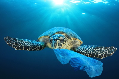 Cleaning the oceans from plastic pollution
Plastic pollution is a widespread problem affecting the marine environment and is a major threat to the health of marine species, some of which are already endangered. CLS and its partners have developed a unique approach to provide a solution using space technology that not only optimizes plastic collection along coastlines and at sea but is also capable of identifying sources of pollution, providing stakeholders with the necessary tools to fight against plastic pollution.
Learn more about tracking macro plastics
Coastal resilience
Coastlines only make up about 8% of the Earth’s land but they have about 26% of all biological diversity providing refuge and food to seabirds, fish, and marine mammals. Coastlines and low-lying coastal areas are changing and, according to the IPCC, sea level rise caused by climate change will increase coastal erosion worldwide.
 With this in mind, CLS recently led an ambitious project, LittoSCOPe, which, by using satellites to identify impacted areas and assess the risk of marine submersion, developed a tool dedicated to coastal areas to help adapt to the effects of climate change.
This tool, a platform, provides data on land elevation and sea level and integrates socio-economic data and land use. An easy to use decision support tool, the platform provides dynamic risk indicators as well as an estimate of the damages caused to surrounding areas by the submersion.