← Back
Vendée Globe: Icebergs detected on the skippers’ route: Antarctic Exclusion Zone raised by 5 degrees to improve the safety of skippers

Since 2008, CLS, Official Supplier of ice data for the Vendée Globe, has been using technologies and satellites designed and deployed by CNES (French National Center for Space Studies) and ESA (European Space Agency) to detect icebergs threatening the skippers’ route.
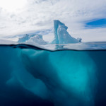
This year, a dozen satellites, including Sentinels 1 and 3, and no less than 300 radar images will be used to detect these UFOs (Unidentified Floating Objects) that haunt any sailor sailing in the southern seas.
CLS radar imagery analysts have detected around 20 questionable icebergs in about 50 images in the Crozet and Kerguelen area of the French Southern and Antarctic Lands (TAAF). Faced with these doubts, the Vendée Globe race management, after consulting with CLS teams, did not hesitate to raise the Antarctic Exclusion Zone by 5 degrees further north, lengthening this safety cordon by more than 400km. The Antarctic Exclusion Zone is a virtual zone where the skippers are forbidden to sail under risk of encountering these icy monsters, a crossing that could endanger their safety but also cost them penalties.
Let us also remember that space systems play an important role in rescue at sea. The rescue of Kevin Escoffier proved this on December 1, when the skipper triggered his COSPAS-SARSAT satellite distress beacon, the starting point of a rescue chain to which he owes his life. We’ll take a look back at the heroic night a little further down in the press release.
For those who could not attent the press conference “Space, the Vendée Glace ice watch” which took place on December 3rd at 3 p.m. find here the replay.
This replay is reusable for your topics except for Loick Perron’s videos (beginning of the conference), to obtain them, please contact CLS.
 Jacques Caraës, Vendée Globe Race Director
“CLS, which works closely with CNES and ESA, is a key partner of the Vendée Globe. We could no longer imagine a race like the Vendée Globe without iceberg detection and risk mitigation services like theirs.
CLS has developed unparalleled expertise in iceberg detection, thanks to its innovative solutions, its teams are helping us to make the race safer by detecting these ice monsters that threaten skippers. And nothing would be possible without space agencies such as CNES and ESA, which are developing impressive and often unique space segments in the world. In advanced space applications, unity is a formidable force.”
 Antarctic Exclusion Zone: major danger zone not to be crossed
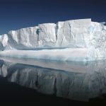
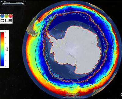
The Antarctic Exclusion Zone (AEZ): 26,223 km in circumference, surrounds Antarctica and is home to several million icebergs. Among them, thousands have been clearly identified thanks to ESA and CNES satellites, and by the expertise of CLS teams in Earth observation and analysis.
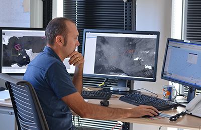
Since July, CLS imagery analysts have been scanning altimetry curves and radar images for icebergs that could threaten seasoned Vendée Globe skippers.
A first version (V0) of this Antarctic Exclusion Zone was communicated this summer to the Vendée Globe Race Direction, then before the start: a slightly modified version (V1) was transmitted to the skippers.
Crucial information which impacts the race distance, performacnce results and the lives and equipment carried on board.
Space surveillance before and during the race
Step 1: Predicting risk areas with altimetry
Well before the start of the race, CLS teams worked on data from 4 altimetry satellites, normally used to measure mean sea level, and diverted from their primary use to pre-detect icebergs.
This was a very important step that allowed them to know where to focus their research with radar images before the race, but also in operational mode when the skippers are in the southern zones.
 Sophie Coutin-Faye, head of altimetry projects at CNES: “Space altimetry consists of taking radar altimeters on board satellites orbiting the Earth, capable of measuring the height of the oceans with centimeter level accuracy. To put it simply, the principle of altimetry measurement consists of emitting a wave towards the ocean from a satellite whose position is known to within a few millimeters, and measuring its return travel time. The height of the water surface overflown by the satellite is thus deduced. The applications are numerous, including the well-known monitoring of the rise in the average level of the oceans in connection with global warming, but also that of a better understanding of ocean currents in all oceans which is particularly useful for navigation.
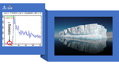
This high-precision technology was developed in the 1990s jointly by CNES and NASA and is now being extended to other agencies such as ESA. For the pre-detection of icebergs, it is important to know that when the altimeter beam encounters a mountain of ice, it causes a modification of the return echo (see graph) that must be analyzed to conclude that this is indeed the signature of icebergs. Obviously, we could not deploy altimetry satellites for this use alone, but I find it very interesting to have such unexpected applications as securing an ocean race such as the Vendée Globe.”
Step 2: Detect the most threatening icebergs
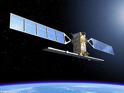
 ESA has given the race privileged access to the European Sentinel-1A & 1B satellites. These satellites, funded by the European Commission, are capable of taking radar images, day or night, and can even see through clouds.
The 400km x 400km images have a resolution of 50m.
The ESA satellites, Sentinel-1A & 1B were programmed well in advance of the race to provide images until the last skipper leaves the ice. The satellite programming was adjusted according to the routes and needs of the race, between mid-November and the end of December. To complete this strategic vision, CLS also uses the privately owned Canadian satellite Radarsat-2, which on order can provide a resolution of up to 25m.
 Simonetta Cheli, Head of Strategy, Program and Coordination Office of ESA’s Earth Observation Unit: “Sentinel-1 is a series of Earth observation satellites developed by the European Space Agency as part of the European Copernicus program, the first of which was placed in orbit in 2014.
The objective of this program is to provide European countries with complete and updated data to enable them to control and monitor environnement. We are delighted that these data are now being used to improve the safety of Vendée Globe skippers”.
Step 3: Track detected icebergs
Each detected iceberg is assigned a unique identifier and is then ingested into a drift and melt model developed by CLS.
It’s possible to observe icebergs measuring 50 or 25m in size, but it’s the small icebergs (growlers) resulting from the melting and dislocation of the larger ones that are dangerous for the boats in the race.
 This is why the use of the CLS drift model simulates the drift but also the break-up and melting of the icebergs in order to define risk zones (orange and red squares on the images).
This drift and melting model takes into account the currents, the wind, the sea state (sea level height, etc.), the surface temperature as well as the shape and size of the iceberg.
As a result, CLS is able to provide Vendée Globe organizers with maps of the Southern Ocean with the location of iceberg populations and forecasts of their drift. CLS, in partnership with CNES and ESA, is supporting the Vendée Globe race management in its decision-making process.
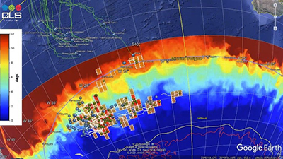
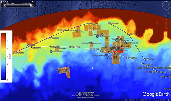
Crozet Zone – Kerguelen : Antarctic Exclusion Zone raised as Icebergs detected on the skippers’ route
About twenty icebergs were detected above the line, in nearly fifty radar images, in the Crozet- Kerguelen zone, in the TAAF, last week, which caused the elevation of the AEZ by 5 degrees, extending the circumference of this security cordon by more than 400km.
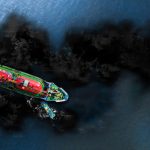
In the figure below, the blue line is the new AEZ (V2), the white line (V1), the blue flakes are the icebergs detected, the white filaments represent their drift and the orange and red squares display the risk zones.
Sophie Besnard, Director of International Affairs, in charge of managing the Vendée Globe project at CLS : “Since the start of the race, we have detected around 60 icebergs which have been identified as requiring close monitoring, most of them under the AEZ, except for those detected off the island of Crozet. In the Indian Ocean there is nothing for the moment, in the Pacific, there are a few icebergs, in front of the Ross Sea, where there is an area of very cold water. This year we are in a situation of lower iceberg density than in previous years. All our teams are mobilized, we still have half of the images to analyze by the end of the race out of the 300 planned. The most complicated period is after the passage of Cape Horn, the leader should pass this tense point a little before Christmas, the last one should pass it at the end of January. We are proud to be the Official Ice Data Supplier of the Vendée Globe and to be able to use the technologies and satellites developed and placed in orbit by CNES and ESA.”
Read the news about Kévin Escoffier’s rescue
About
 Collecte Localisation Satellites (CLS)
CLS, a subsidiary of CNES and CNP, is an international company, a pioneer in providing Earth observation and monitoring solutions since 1986. Its vision is to imagine and deploy innovative solutions to understand and protect our Planet and manage our resources sustainably. CLS employs 750 people at its headquarters in Toulouse and at its 27 other sites around the world.
The company operates in 5 strategic business areas: sustainable fisheries management, environmental & climate monitoring, maritime safety, fleet management and energy & mining.
In particular, the company provides satellite services based on the location and collection of environmental data (100,000 beacons are processed every month, drifting buoys, beacons equipping animals, fishing or commercial fleets, etc.). ), ocean and inland water observation (more than 20 instruments on board satellites deliver daily information to CLS about the world’s seas and oceans), and the monitoring of land and maritime activities (several thousand radar images are processed and several hundred hours of flight time by UAVs are analyzed each year by their teams).
Committed to a sustainable planet, the company works daily for Earth, from space.
 Centre National d’Etudes Spatiales (CNES)
The CNES (Centre National d’Etudes Spatiales) is the public establishment in charge of proposing French space policy to the Government and implementing it within Europe. It designs and puts satellites into orbit and invents the space systems of tomorrow; it promotes the emergence of new services, that are useful on a daily basis.
CNES, created in 1961, is at the origin of major space projects, launchers and satellites, and is the natural industry representative to push innovation. The CNES has nearly 2,500 employees, men and women who are passionate about space, which opens up infinite, innovative fields of applications and operates in five areas: Ariane, science, observation, telecommunications and defense. CNES is a major player in technological innovation, economic development and industrial policy in France. It also establishes scientific partnerships and is involved in numerous international cooperation projects. France, represented by CNES, is the main contributor to the European Space Agency (ESA).
 Vendée Globe
The Vendée Globe race, a solo round-the-world sailing race, holds a very special place in the world of nautical competitions and is considered a major sailing event. On the occasion of the 9th edition of the race, which started on November 8, 2020 from Les Sables d’Olonne, the sporting line-up of 33 skippers, including 6 women, is varied and of high caliber. The arrivals can be estimated around mid-January 2021. The record to be beaten is 74 days and 3 hours at sea.
 ESA
ESA
The ESA (European Space Agency) is Europe’s gateway to space. Its mission is to manage Europe’s space capabilities and to ensure that European citizens continue to benefit from investments in space. ESA is an international organization with 22 member states.
By coordinating the financial and intellectual resources of its members, ESA is able to undertake programmes and activities that go far beyond what each of these countries could achieve individually. The Agency develops the launchers, satellites and ground facilities that enable Europe to play a leading role on the world space scene.
Today, ESA develops and places in orbit satellites for Earth observation, navigation, telecommunications and astronomy, sends probes to the far reaches of the Solar System and participates in the human exploration of space.
THOMAS RUYANT – LinkedOut
What is The Race for Change?
It is the meeting of 3 universes – sport, business and a cause supported by an NGO – to mobilize the largest number of people in the fight against exclusion and allow for a rescale in social inclusion in France. On November 8, Thomas Ruyant set off on the Vendée Globe, a solo, non-stop, unassisted circumnavigation of the world on board the latest IMOCA hydrofoil boat (launched in September 2019). With Advens, its main partner, they have decided to offer visibility and branding to LinkedOut, the network for those who do not have one. For his second participation, Thomas is committed with the firm intention of taking the lead in order to put his performance at the service of a major societal challenge and thus accelerate the Race for Change!
Find out more:
- Thomas Ruyant, northern skipper ranked among the favorites for the next Vendée Globe
- LinkedOut, positive tech device that puts people in precarious situations back to work
- Advens, France’s leading pure-player in cyber security
- Swiss Life : benchmark player in insurance and asset management
About Advens, main partner:
As France’s leading pure player in cyber security, Advens supports companies, local authorities and public institutions on a daily basis to help them get ahead of the game and make security a differentiating asset. Driven by its raison d’être to make digital technology an opportunity for a fairer and more sustainable world, Advens has chosen to offer the naming and visibility of its boat to the positive tech LinkedOut device, to enable a rescaling in social inclusion in France.
About Thomas Ruyant:
From his numerous victories (Mini-Transat 2009, Route du Rhum 2010 in Class40, Transat AG2R La Mondiale 2018 with Adrien Hardy), his rarer failures (including a forced withdrawal from the last Vendée Globe), Thomas Ruyant has forged a method based on a need for results, the product of a very Nordic pragmatism that leaves no room for theatrics. Without a model or mentor, building a project with conviction in his own image, ambitious, determined, innovative, Thomas intends to be among the first places aboard LinkedOut, in the most beautiful, the most important, race.