Flood Risks: Mapping Data
Reliable flood detection, monitoring and assessment on a global scale.
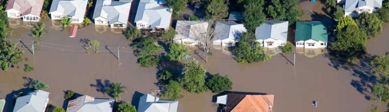
 Floods: An ever growing and more deadly hazard
Of all natural hazards, floods are the most frequent and the most deadly. The latest monsoons in Pakistan caused devastating floods that affected more than 33 million people and killed nearly 1,800 civilians. With catastrophic events such as these becoming increasingly common due to climate change, predicting them has never been more important.
CLS puts 30 years of Earth Observation at the service of civil protection
CLS started monitoring sea, lake and river levels from Space as far back as the 1990s. The company processes, disseminates and archives data from thousands of hydrological stations all over the planet. As a result, over the last decade CLS has become a key contributor at European level to emergency mapping and in particular to the identification, mapping and impact of floods.
CLS offers all of this hydrological expertise to governments and agencies responsible for the protection of civilians.
 A network of complementary partner
In order to provide the best possible service, CLS works with a range of key stakeholders including governments, the French space agency (CNES), the European Commission’s Joint Research Center (JRC), plus a number of startups offering complementary services in-situ.
The benefits of CLS for flood risk mapping
- A round-the-clock service.
- Unique data expertise.
- Multi-sensor processing.
- Before and after mapping, required for damage and flood level assessment.
100+ apid maps created by CLS in emergency situations, as part of the Copernicus Emergency Management Service.
For nearly 10 years, CLS has been using its altimetry expertise for water analysis and management. It measures, from Space and in near-real time, water height, volume and flow at over 10,000 locations for a range of projects.
CLS processes data from more than 1,000 hydrological stations worldwide.
Flood mapping and monitoring
Contextual analysis
Adaptation of our data processing and analysis to ensure scalable and effective tools:
- A highly responsive team and a flexible timescale.
- On-call services for the supply of rapid damage mapping within a few hours.
- More than 15 years of flood monitoring expertise.
Integration of all relevant data to enhance the maps produced and fine-tune the data.
 Methodology
- Strategic use of optical and radar data to cover the greatest possible surface area with the highest possible level of precision given the prevailing atmospheric conditions (VHR and MR imagery)
- Cross-referencing with local and in-situ data to fine-tune the analysis
- Global coverage
Production
- Expertise in computer-assisted photo interpretation for damage assessment and flood level monitoring.
- Use of flood-detection algorithms developed by our experts.
Services provided
- Dynamic mapping to track flood evolution
- Delivery of the databases produced
- Service access via a platform
Copernicus Emergency Management Service (CEMS)
As a member of the European Commission’s Copernicus Emergency Management Service, CLS has produced more than 100 rapid maps of extreme events (floods, fires, earthquakes).
CLS experts are able to process satellite images in less than six hours, to produce:
- Boundary information, along with regular updates;
- Classification information, with detailed damage assessments.

FloodDam
On behalf of the French space agency CNES, CLS has developed an automatic rapid flood mapping system using radar and optical images, plus a platform displaying the observed flooded areas and simulated hazard maps.
Known as FlooDAM, the system has already been tested in a number of hydrological basins around the world, with great success.